Tel Gezer National Park
Nesher, IL
- Location
- Nesher, IL
- Category
- national parks nature reserves
- Coordinates
- 31.859443, 34.92164
- Best time
- Morning or early afternoon
- Weather tip
- Check the local forecast before visiting.
Overview
Tel Gezer National Park preserves the remains of one of the most prominent ancient Canaanite and Israelite cities in the Shephelah region. Strategically positioned at the junction of the Via Maris and the road leading to Jerusalem, it served as a vital administrative and military hub for millennia. Visitors today can explore an extensive archaeological site that features a circular hiking trail offering panoramic views of the coastal plain and the Judean Mountains. The site is a premier destination for those seeking historical depth and scenic vistas, making it a standout choice for trip ideas in the central region.
As you walk through the park, you will encounter significant archaeological findings, including the famous Gezer Calendar replica, the Canaanite water system, and the monumental 'Solomonic' Gate. The park is managed to highlight the intersection of human engineering and natural topography. For travelers looking for what to do in the area, the site provides a blend of rigorous historical exploration and a peaceful outdoor experience. The well-marked paths lead through various strata of history, from the Bronze Age to the Hellenistic period, ensuring that every visit offers a comprehensive look at the evolution of urban fortification and water management in the ancient Near East.
General information
Tel Gezer National Park preserves the remains of one of the most prominent ancient Canaanite and Israelite cities in the Shephelah region. Strategically positioned at the junction of the Via Maris and the road leading to Jerusalem, it served as a vital administrative and military hub for millennia. Visitors today can explore an extensive archaeological site that features a circular hiking trail offering panoramic views of the coastal plain and the Judean Mountains. The site is a premier destination for those seeking historical depth and scenic vistas, making it a standout choice for trip ideas in the central region.
As you walk through the park, you will encounter significant archaeological findings, including the famous Gezer Calendar replica, the Canaanite water system, and the monumental 'Solomonic' Gate. The park is managed to highlight the intersection of human engineering and natural topography. For travelers looking for what to do in the area, the site provides a blend of rigorous historical exploration and a peaceful outdoor experience. The well-marked paths lead through various strata of history, from the Bronze Age to the Hellenistic period, ensuring that every visit offers a comprehensive look at the evolution of urban fortification and water management in the ancient Near East.
Did you know
- The Gezer Calendar, discovered here in 1908, is considered one of the oldest known examples of Hebrew writing, dating back to the 10th century BCE.
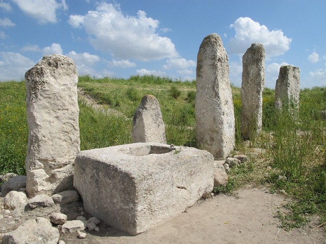
- The site features ten massive standing stones, known as monoliths, which are believed to have been part of a Canaanite 'High Place' for ritual ceremonies.
- Gezer is mentioned in the Bible as a dowry given by the Pharaoh of Egypt to King Solomon upon his marriage to Pharaoh's daughter.
History
Tel Gezer boasts over 3,000 years of continuous habitation, beginning in the Chalcolithic period. Its strategic importance peaked during the Middle Bronze Age when the Canaanites constructed massive fortifications and a sophisticated water system. The city is famously associated with the biblical accounts of King Solomon, who is credited with rebuilding its walls and gates. Throughout the centuries, Gezer fell under the control of various empires, including the Egyptians, Assyrians, and Babylonians. In the 2nd century BCE, it served as a stronghold for the Seleucids during the Maccabean Revolt before being captured by Simon Maccabeus. Archaeological excavations led by R.A.S. Macalister in the early 20th century revealed the site's multi-layered history, uncovering the Gezer Calendar and the monumental six-chambered gate.
Cultural significance
Tel Gezer holds immense cultural and religious significance due to its frequent mentions in ancient texts, including the Amarna letters and the Hebrew Bible. It serves as a physical record of the transition between Canaanite and Israelite cultures. The discovery of the Gezer Calendar provided linguists and historians with crucial insights into ancient agricultural cycles and the evolution of the Northwest Semitic alphabet. Furthermore, the site’s 'High Place' offers a rare glimpse into Canaanite cultic practices, making it a focal point for the study of ancient Near Eastern religions. Its enduring legacy is reflected in its status as a landmark that bridges the gap between archaeological evidence and historical narrative.
Geography and landscape
Located on the western edge of the Shephelah (Judean foothills), Tel Gezer sits on a prominent ridge that rises approximately 225 meters above sea level. This elevation provided the ancient city with a commanding view of the coastal plain to the west and the approach to the Jerusalem hills to the east. The landscape is characterized by rolling limestone hills and fertile valleys that supported the city's agricultural economy. The park features a circular trail that navigates the tel's summit, allowing visitors to experience the natural flora of the region while observing the strategic topography that made Gezer an impregnable fortress for centuries.
More facts
- Imported from OSM batch
Visitor links
Nearby attractions
- Solomon's gate 15 m
- the 10 monuments 86 m
- Tel Gezer 87 m
- Water Works 186 m
- Gezer Central District - 236 m
- Gat 1396 m
- כתובת תחום גזר מס. 5 1990 m
- כתובת גזר מס. 12 2262 m