Ritterstein 274 "Stüterhof"
DE
- Location
- DE
- Category
- iconic bucket list
- Coordinates
- 49.4435317, 8.0371735
- Best time
- Morning or early afternoon
- Weather tip
- Check the local forecast before visiting.
Overview
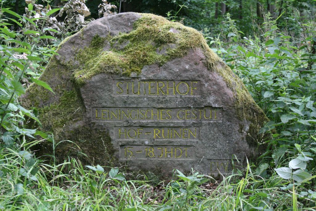
Ritterstein 274, known as 'Stüterhof,' is a historical marker located in the Palatinate Forest, west of Bad Dürkheim. Situated between the Stüterberg and Stüterkopf peaks, this sandstone monument serves as a permanent record of a vanished settlement. Historically, the site originated from a stud farm (Gestüt) established by the Counts of Leiningen, which eventually evolved into a small village. Over time, the location also served as the site for a hunting lodge utilized by the Leiningen nobility, marking it as a significant point of interest for those exploring the region's aristocratic heritage. Today, hikers and history enthusiasts visit the site to engage with the remnants of local medieval and early modern land use. The Ritterstein is part of a larger network of markers throughout the Palatinate Forest, offering visitors a unique opportunity to connect with the area's past while enjoying the natural surroundings. For those seeking meaningful trip ideas, this marker provides a tangible link to the administrative and social history of the Leiningen lands. It is an excellent stop for outdoor enthusiasts interested in local attractions that combine forest trekking with historical discovery. Visitors should plan their trip for the morning or early afternoon to take advantage of natural light when locating the stone, and it is always advisable to check the local weather forecast before heading into the forest trails.
General information
Ritterstein 274, known as 'Stüterhof,' is a historical marker located in the Palatinate Forest, west of Bad Dürkheim. Situated between the Stüterberg and Stüterkopf peaks, this sandstone monument serves as a permanent record of a vanished settlement. Historically, the site originated from a stud farm (Gestüt) established by the Counts of Leiningen, which eventually evolved into a small village. Over time, the location also served as the site for a hunting lodge utilized by the Leiningen nobility, marking it as a significant point of interest for those exploring the region's aristocratic heritage. Today, hikers and history enthusiasts visit the site to engage with the remnants of local medieval and early modern land use. The Ritterstein is part of a larger network of markers throughout the Palatinate Forest, offering visitors a unique opportunity to connect with the area's past while enjoying the natural surroundings. For those seeking meaningful trip ideas, this marker provides a tangible link to the administrative and social history of the Leiningen lands. It is an excellent stop for outdoor enthusiasts interested in local attractions that combine forest trekking with historical discovery. Visitors should plan their trip for the morning or early afternoon to take advantage of natural light when locating the stone, and it is always advisable to check the local weather forecast before heading into the forest trails.
Did you know
- Ritterstein 274 is part of a series of over 300 sandstone markers in the Palatinate Forest documenting historical sites.
- The name 'Stüterhof' derives from the German word 'Gestüt,' referring to the historic stud farm located there.
- The site was once under the jurisdiction of the powerful Counts of Leiningen.
History
The history of Stüterhof is tied to the territorial influence of the Counts of Leiningen in the Palatinate region. Initially established as a stud farm, the site transitioned into a small village, reflecting the agricultural and economic development of the forest clearings during the medieval period. The subsequent construction of a hunting lodge highlights the area's later use as a recreational and administrative retreat for the nobility. The village eventually fell into disrepair or was abandoned, leaving the Ritterstein as one of the few remaining physical indicators of its former existence.
Cultural significance
The Ritterstein markers are culturally significant as they preserve the memory of the Palatinate Forest's changing landscape. They transform the forest into an open-air museum, allowing the public to understand the historical context of land use, from noble hunting grounds to rural settlements. By marking the location of the former Stüterhof village, the stone prevents the loss of local history that would otherwise be reclaimed by nature, serving as a vital link between modern hikers and the generations that lived and worked in these woods centuries ago.
Geography and landscape
The site is nestled deep within the Palatinate Forest, characterized by dense deciduous and coniferous woodland. It is topographically situated in the saddle between the Stüterberg and Stüterkopf elevations. The terrain is typical of the Haardt mountain range, featuring rugged sandstone outcrops and undulating forest paths. This location provides a secluded, quiet atmosphere, typical of the remote areas of the Palatinate Forest, making it a scenic destination for those who enjoy traversing trails that wind through historical landscapes.
More facts
- Imported from OSM batch
Visitor links
Nearby attractions
- Ritterstein 265 "Alte Glashuette" 1871 m
- Ritterstein 279 "Matternshuette" 2096 m
- Ritterstein 278 "Ruine Wolfenhütte" 2299 m
- Ritterstein 261 "An der Pottasch-Hütte" 2996 m
- Ritterstein 270 "Ruine Jagdhaus Schaudichnichtum" 3836 m
- Ritterstein 269 "Ebene Kehrdichannichts" 3985 m
- Ruine Wachturm Murrmirnichtviel 4142 m
- Ritterstein 305 "Lellebebbel-Pädel" 5580 m