Funkturm Groß Reken Melchenberg
DE
- Location
- DE
- Category
- viewpoints natural phenomena
- Coordinates
- 51.839592, 7.0398792
- Best time
- Morning or early afternoon
- Weather tip
- Check the local forecast before visiting.
- Opening hours
- Mo-Su,PH sunrise-sunset
Overview
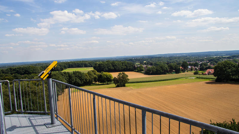
The Funkturm Groß Reken, situated on the Melchenberg, serves as a prominent landmark and observation point in the Reken region of North Rhine-Westphalia, Germany. Standing as a functional telecommunications tower, it provides visitors with a unique vantage point to survey the surrounding Westmünsterland landscape. While its primary purpose remains technical infrastructure, the site is a popular destination for those seeking a panoramic view of the local topography. Visitors can expect a quiet, natural environment characterized by the gentle, rolling hills typical of the region. As one of the notable local attractions, the tower offers a clear perspective on the rural character of the area, making it an ideal stop for hikers, cyclists, and those interested in regional geography. The ascent provides a rewarding visual experience, particularly on clear days when visibility extends across the forested patches and fields. For those planning trip ideas in the area, the Melchenberg location offers a blend of technological history and natural beauty, providing a peaceful retreat away from urban centers. It is recommended to visit during the morning or early afternoon to take advantage of optimal lighting conditions for photography and observation. Always check the local weather forecast before heading out, as visibility and accessibility can vary depending on atmospheric conditions.
General information
The Funkturm Groß Reken, situated on the Melchenberg, serves as a prominent landmark and observation point in the Reken region of North Rhine-Westphalia, Germany. Standing as a functional telecommunications tower, it provides visitors with a unique vantage point to survey the surrounding Westmünsterland landscape. While its primary purpose remains technical infrastructure, the site is a popular destination for those seeking a panoramic view of the local topography. Visitors can expect a quiet, natural environment characterized by the gentle, rolling hills typical of the region. As one of the notable local attractions, the tower offers a clear perspective on the rural character of the area, making it an ideal stop for hikers, cyclists, and those interested in regional geography. The ascent provides a rewarding visual experience, particularly on clear days when visibility extends across the forested patches and fields. For those planning trip ideas in the area, the Melchenberg location offers a blend of technological history and natural beauty, providing a peaceful retreat away from urban centers. It is recommended to visit during the morning or early afternoon to take advantage of optimal lighting conditions for photography and observation. Always check the local weather forecast before heading out, as visibility and accessibility can vary depending on atmospheric conditions.
Did you know
- The Melchenberg is the highest elevation in the municipality of Reken.
- The tower serves a dual purpose: supporting telecommunications infrastructure and providing public observation.
- The site is a popular waypoint for regional cycling and hiking trails.
History
The Melchenberg has long been a significant geographical reference point in the Reken area. The construction of the current telecommunications tower was driven by the need for enhanced regional connectivity in the late 20th century. Over time, the structure was integrated into the local tourism framework, as the elevation naturally attracted visitors looking for a vantage point. While the tower itself is a modern engineering installation, its presence on the Melchenberg continues a long tradition of utilizing this specific high point for signaling and observation purposes within the Westmünsterland region.
Cultural significance
The Funkturm on the Melchenberg represents the intersection of modern utility and recreational land use in rural Germany. It acts as a visual anchor for the community of Reken, symbolizing the modernization of infrastructure within a traditional, agricultural landscape. For the local population, the tower is a recognized landmark that defines the horizon. It has become a cultural touchstone for residents and visitors alike, representing the region's commitment to maintaining accessible natural spaces while supporting the necessary technological advancements of the digital age.
Geography and landscape
The Melchenberg is a prominent hill located in the Westmünsterland region of North Rhine-Westphalia. The landscape surrounding the Funkturm is defined by a mosaic of agricultural fields, dense patches of deciduous and coniferous forests, and small, scattered rural settlements. The terrain is characterized by gentle undulations typical of the Münsterland plain, providing long-range visibility over the horizon. The tower serves as a high-altitude observation platform that allows the eye to trace the patterns of land use in the region, from the patchwork of farms to the distant tree lines that define the local ecosystem.
More facts
- Imported from OSM batch
Visitor links
Nearby attractions
- Station VI 2283 m
- Teufelsteine 4293 m
- Hermann-Löns-Denkmal 8719 m
- Bertha, Hugo und Selma Lebenstein 9443 m
- Barackenlager Lette 9752 m